
טעקע:Asia 800ad.jpg
גרייס פון דעם פארויסקוק: 800 × 463 פיקצעלן. אנדערע רעזאלוציעס: 320 × 185 פיקצעלן | 640 × 370 פיקצעלן | 1,024 × 593 פיקצעלן | 1,280 × 741 פיקצעלן | 2,099 × 1,215 פיקצעלן.
בילד מיט אַן הױכע רעזאָלוציע (2,099 × 1,215 פיקסעל, טעקע גרייס: 809 קילאבייטן, טיפ MIME: image/jpeg)

|
יש ליצור מחדש את התמונה historical map הזו באמצעות גרפיקה וקטורית כדוגמת קובץ SVG. לפעולה זו מספר יתרונות, כפי שניתן לקרוא (באנגלית) בדף Commons:Media for cleanup. אם ברשותכם קובץ SVG, אנא העלו אותו. לאחר מכן, החליפו תבנית זו בתבנית
{{vector version available|שם הקובץ.svg}} |


רעזומע
| דעסקריפציע |
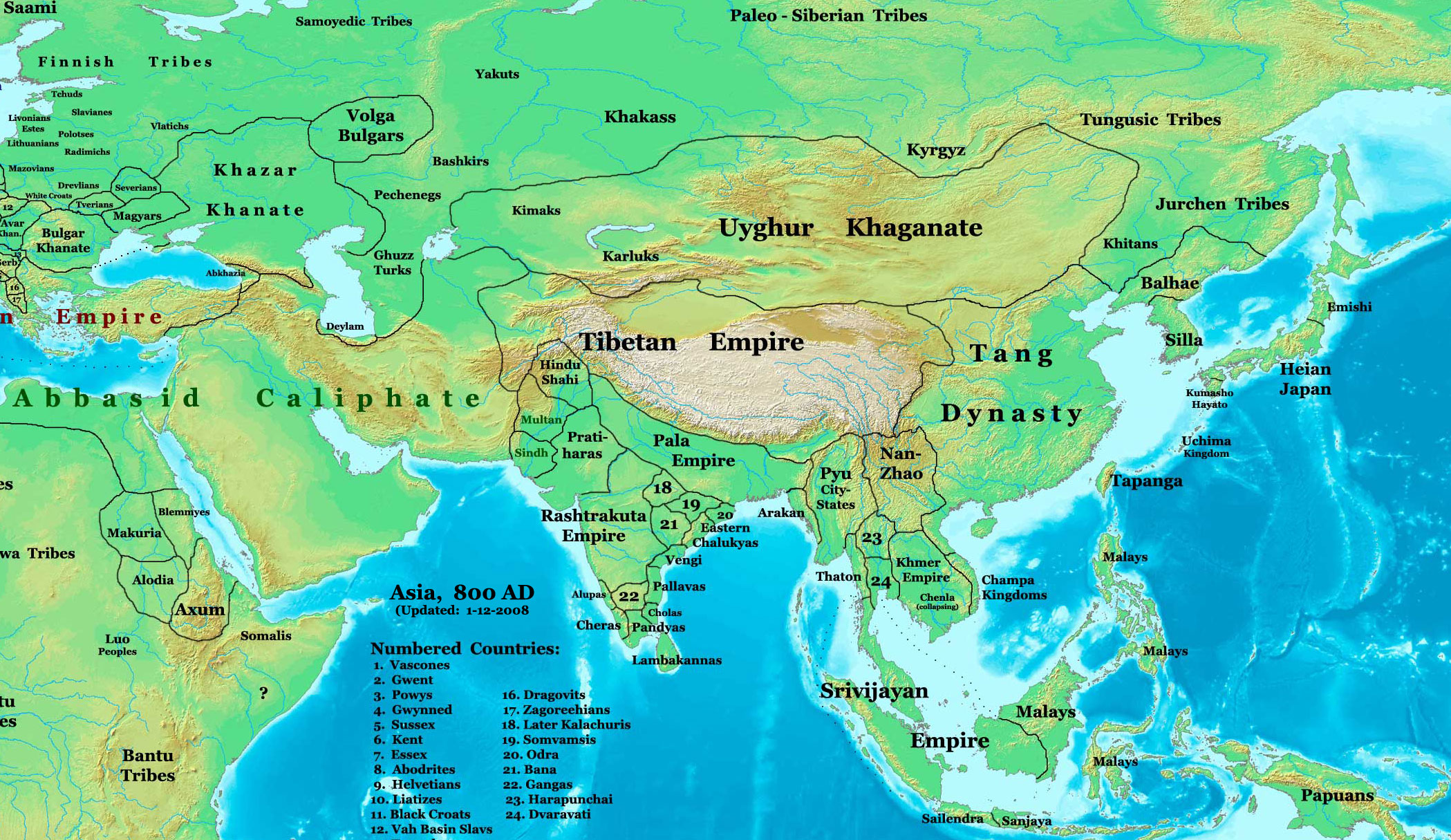
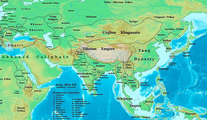
English: This image is a zoomed-in version of Image:East-Hem_800ad.jpg (Eastern Hemisphere in 800 AD).
Author: Thomas A. Lessman. Source URL: http://www.ThomasLessman.com/History/images/East-Hem_800ad.jpg. Image was created by me (Thomas Lessman) based on map of Eastern Hemisphere in 800 AD. Image is free for public and/or educational use. I would appreciate a mention if this image is used elsewhere. If anyone is interested in helping further this work, please contact Thomas Lessman at talessman@yis.us. Other Historical Maps by Thomas Lessman
|
| דאַטע | 22 אָקטאָבער 2007 (תאריך העלאה מקורי); 29 יאַנואַר 2008 (last version) |
| מקור | Transferred from en.wikipedia to Commons by Vinhtantran using CommonsHelper. |
| שרייבער | Talessman מווויקיפעדיע הענגליש |
| אַנדערע ווערסיעס |
 |


ליצענץ:
Talessman מווויקיפעדיע הענגליש, בעל זכויות היוצרים על היצירה הזאת, מפרסם אותה בזאת תחת הרישיונות הבאים:

|
מען גיט רשות צו קאפירן, פארשפרייטן אדער מאדיפיצירן דעם דאקומענט, לויט די באדינגונגען פונעם גנו פֿרייען דאקומענטאציע ליצענץ, ווערסיע 1.2 אדער א שפעטערע ווערסיע פארעפנטלעכט דורכן פרייע ווייכווארג פונדאציע; מיט קיין אומפארענדערלעכע פאראגראפן, און קיין פאדערשטע אדער הינטערשטע דעק טעקסטן. א קאפיע פונעם ליצענץ איז איינגעשלאסן אינעם אפטייל גנו פֿרייער דאקומענטאציע ליצענץ. |
די טעקע ווערט ליצענצירט אונטער דער Creative Commons 3.0 נישט צוגעפאַסטער ליצענץ.
צושרײַבונג: Talessman מווויקיפעדיע הענגליש
- איר מעגט:
- באַטייליקן – קאפירן, פֿאַרשפרייטן און איבערשיקן די ווערק
- ווידערמישן – באַאַרבעטן די ווערק
- אונטער די פאלגנדע תנאָים:
- צושרײַבונג – איר מוזט צושרײַבן די ווערק אויפן שטייגער ספעציפֿירט דורכן שאַפֿער אדער ליצענץ־האַלטער (אבער נישט אין אזוינעם אופן אַז עס זעט אויס אַז זיי שטיצן אונטער אײַך אדער אײַער ניץ פון דער ווערק).
איר מעגט אויסקלויבן נארוועלכן ליצענץ.
יומן העלאה מקורי
The original description page was here. All following user names refer to en.wikipedia.
- 2008-01-29 22:50 Talessman 2099×1215×8 (828763 bytes) corrected borders of Tibet and others
- 2007-12-10 23:50 Talessman 2106×1450×8 (911289 bytes) (Correct image uploaded this time; earlier upload was the old version...)
- 2007-12-10 23:48 Talessman 1950×1193×8 (695931 bytes) Uploaded most recently corrected version (as of 12-09-2007)
- 2007-10-31 20:39 Talessman 1950×1193×8 (695931 bytes) Corrected borders of Korea, added info on Far eastern islands
- 2007-10-22 19:15 Talessman 1673×1062×8 (553343 bytes) Author: Thomas A. Lessman. Source URL: http://www.ThomasLessman.com/History/images/East-Hem_800ad.jpg. Image was created by me (Thomas Lessman) based on map of Eastern Hemisphere in 800AD. Image is free for public and/or educational use. I would appreciat
היסטאריע פֿון דער טעקע
קליקט אויף א דאטע/צײַט צו זען דאס בילד אזוי ווי עס איז דעמאלסט געווען
| דאַטע/שעה | געמינערטע בילד | געמעסטן | באניצער | קאָמענטאַר | |
|---|---|---|---|---|---|
| איצטיקע | 04:46, 23 יוני 2008 | | 1,215 × 2,099 (809 קילאבייטן) | File Upload Bot (Magnus Manske) | {{BotMoveToCommons|en.wikipedia}} {{Information |Description={{en|This image is a zoomed-in version of [http://en.wikipedia.org/wiki/Image:East-Hem_800ad.jpg Eastern Hemisphere in 800 AD]. [[:en:Image:East-Hem_800ad.jpg|thumb|300px|left|Eastern Hemispher |
טעקע באַניץ
נישטא קיין בלעטער וואס ניצן די טעקע.
גלאבאלע טעקע־פארווענדונג
די פאלגנדע אנדערע וויקיס ניצן די דאזיקע טעקע:
- באניץ ביי azb.wikipedia.org
- באניץ ביי ba.wikipedia.org
- באניץ ביי bn.wikipedia.org
- באניץ ביי en.wikipedia.org
- Bangladesh
- West Bengal
- History of Bangladesh
- Jaisalmer
- Gauḍa (city)
- History of Bihar
- Śāntarakṣita
- Pataliputra
- History of Rajasthan
- Horses in East Asian warfare
- Jaisalmer State
- User:Joelton Ivson/Gather lists/24270 – India
- User:Gauravkumar4291/Notes/GS/Cul/Pala Empire
- Horses in ancient and Imperial China
- באניץ ביי fa.wikipedia.org
- באניץ ביי fr.wikipedia.org
- באניץ ביי hi.wikipedia.org
- באניץ ביי incubator.wikimedia.org
- באניץ ביי it.wikipedia.org
- באניץ ביי ka.wikipedia.org
- באניץ ביי kn.wikipedia.org
- באניץ ביי ko.wikipedia.org
- באניץ ביי mai.wikipedia.org
- באניץ ביי my.wikipedia.org
- באניץ ביי ne.wikipedia.org
- באניץ ביי pt.wikipedia.org
- באניץ ביי ru.wikipedia.org
- באניץ ביי sl.wikipedia.org
- באניץ ביי ta.wikipedia.org
- באניץ ביי te.wikipedia.org
- באניץ ביי tt.wikipedia.org
- באניץ ביי uk.wikipedia.org
- באניץ ביי vi.wikipedia.org