טעקע:Moscow satellite image.jpeg

תוכן הדף אינו נתמך בשפות אחרות.
פֿון װיקיפּעדיע

בילד מיט אַן הױכע רעזאָלוציע(1,000 × 1,000 פיקסעל, טעקע גרייס: 396 קילאבייטן, טיפ MIME: image/jpeg)

די טעקע איז פֿון וויקימעדיע קאמאנס און מען מעג זי ניצן אין אנדערע פראיעקטן. די באשרייבונג פון איר טעקע באשרייבונג בלאט דארט ווערן געוויזן אונטן.

רעזומע

דעסקריפציע
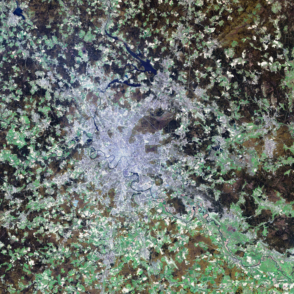
Deutsch: Satellitenbild von de:Moskau
English: satellite image of the city of en:Moscow.
Moscow, the political and economic heart of Russia, sits on the far eastern end of Europe, roughly 1300 kilometers (815 miles) west of the Ural Mountains and the Asian continent. The city boasts a population of over ten million and encompasses an area of 1035 square kilometers (405 square miles). The Moscow River runs through the center of the city, and the Kremlin, the seat of the Russian government, lies in the direct center.
Moscow is thought to have been founded in the 12th Century by Yury Dolgoruky, Prince of Suzdal, who hosted a big feast on the site. The city was shortly after established as a trading route along the Moscow River. Ivan III, who is largely credited with uniting all of Russia, built the Kremlin’s cathedrals and declared Moscow the capital of his new kingdom in the 15th century. In the 17th century, Ivan the Great moved the capital to St. Petersburg, where it remained until the Bolsheviks brought the seat of government back to Moscow in 1918. Over the years the city has been sacked and burnt to the ground by the Tartars, the Poles, and the French. Thanks to the resilient spirit of the Russian people, the city remains as vital as ever. Now it is as capitalist in nature as London or New York, and everything from Big Macs to BMWs can be found on its streets.
The blue-gray pixels in this false-color image are urban areas. The light green areas surrounding the city are farms and the brown regions are more sparsely vegetated areas. This image of Moscow was acquired by the Enhanced Thematic Mapper plus (ETM+), flying aboard the Landsat 7 satellite. July 23, 2002, marks the 30th anniversary of the Landsat program. (Click to read the press release—Celebrating 30 Years of Imaging the Earth.) The Landsat program has been particularly instrumental in tracking land use and land cover changes?such as increased urban growth?over the last three decades.
דאַטע ‏2 אויגוסט 2002‏
מקור NASA Visible Earth project, http://visibleearth.nasa.gov/view_rec.php?id=3434
שרייבער NASA/USGS EROS Data Center Satellite Systems Branch/Landsat 7/ETM+

ליצענץ:

Public domain
This image is in the public domain in the United States because it only contains materials that originally came from the United States Geological Survey, an agency of the United States Department of the Interior. For more information, see the official USGS copyright policy.

Bahasa Indonesia  català  čeština  Deutsch  eesti  English  español  français  galego  italiano  Nederlands  português  polski  sicilianu  suomi  Tiếng Việt  Türkçe  български  македонски  русский  മലയാളം  한국어  日本語  中文  中文(简体)  中文(繁體)  العربية  فارسی  +/−

Public domain קובץ זה נמצא ברשות הציבור מכיוון שהוא נוצר על ידי נאס"א. מדיניות זכויות היוצרים של נאס"א קובעת ש"חומרים של NASA אינם מוגנים בזכויות יוצרים אלא אם צוין אחרת". (דף מדיניות זכויות היוצרים ב-NASA או מדיניות שימוש בתמונות ב-JPL).
אזהרות:
  • שימוש בלוגואים, סמלים וטלאים של נאס"א כפוף להגבלה של החוק בארצות הברית 14 CFR 1221.
  • אתר האינטרנט של נאס"א מכיל תמונות רבות שמקורן מתוכנית החלל הסובייטית/סוכנות החלל הרוסית, וחומרים נוספים של סוכנויות חלל אחרות. קבצים אלו אינם בהכרח תחת רשות הציבור.
  • חומרים מטלסקופ החלל האבל עשויים להיות מוגנים בזכויות יוצרים אם לא מצוין במפורש שהגיעו מSTScI. [1]
  • כל החומרים שנוצרו על ידי חללית SOHO מוגנים בזכויות יוצרים ודורשים הרשאה עבור שימוש מסחרי לא חינוכי. [2]
  • תמונות המוצגות באתר Astronomy Picture of the Day (APOD) עשויים להיות מוגנים בזכויות יוצרים. [3]

בילדקעפלעך

נא להוסיף משפט שמסביר מה הקובץ מייצג

פריטים שמוצגים בקובץ הזה

מוצג העברעאיש

2 אויגוסט 2002

היסטאריע פֿון דער טעקע

קליקט אויף א דאטע/צײַט צו זען דאס בילד אזוי ווי עס איז דעמאלסט געווען

דאַטע/שעהגעמינערטע בילדגעמעסטןבאניצערקאָמענטאַר
איצטיקע05:12, 8 נאָוועמבער 2004געמינערטע בילד פֿאַר דער װערסיע פֿון דער דאַטע 05:12, 8 נאָוועמבער 2004‪1,000 × 1,000‬ (396 קילאבייטן)Ævar Arnfjörð Bjarmason

דער פאלגנדער בלאט ניצט די דאזיגע טעקע:

גלאבאלע טעקע־פארווענדונג

די פאלגנדע אנדערע וויקיס ניצן די דאזיקע טעקע:

מעטאדאטע