
טעקע:Lizars Mexico & Guatimala 1836 UTA (detail of Texas).jpg
גרייס פון דעם פארויסקוק: 694 × 600 פיקצעלן. אנדערע רעזאלוציעס: 278 × 240 פיקצעלן | 555 × 480 פיקצעלן | 889 × 768 פיקצעלן | 1,185 × 1,024 פיקצעלן | 1,357 × 1,173 פיקצעלן.
בילד מיט אַן הױכע רעזאָלוציע (1,357 × 1,173 פיקסעל, טעקע גרייס: 983 קילאבייטן, טיפ MIME: image/jpeg)
רעזומע
| טיטל |
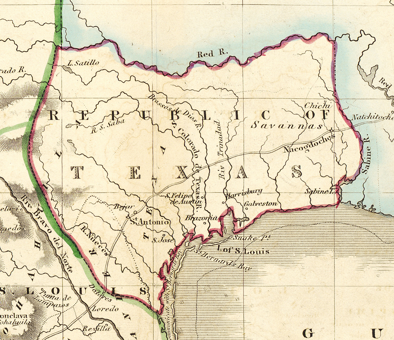
English: Mexico & Guatimala [sic] |
||||||||||||||||||||||||||
| תיאור |
English: Shortly after Texas declared its independence from Mexico in 1836, the Edinburgh painter, engraver, printer, cartographer, lithographer, and publisher William Home Lizars (1788-1859), brother of Daniel Lizars II (1793-1875), updated the original plate for the map of Mexico & Guatemala to include the new republic. He added the towns of Galveston, Harrisburg, Brazoria, S. Felipe de Austin (although recently destroyed), Bejar, and "S. Jose" (probably intended to represent Goliad). Lizars made no further improvements to the general cartographic shape of the republic except to show the Nueces River as the southern boundary and the western boundary curving to the point where the 100th meridian strikes the Red River. The map continues to show Mexico's administrative districts as Spanish Intendencies (Intendencias) and Internal Provinces (Provincias Internas) over fifteen years since Mexico's independence. |
||||||||||||||||||||||||||
| דאַטע | בסביבות 1836 | ||||||||||||||||||||||||||
| מקור | UTA Libraries Cartographic Connections: מאפע / text | ||||||||||||||||||||||||||
| יוצר |
|
||||||||||||||||||||||||||
| ייחוס |
English: The University of Texas at Arlington Libraries Special Collections, Gift of Lewis & Virginia Buttery |
||||||||||||||||||||||||||
| Geotemporal data | |||||||||||||||||||||||||||
| Map location | טעקסעס | ||||||||||||||||||||||||||
| Georeferencing | If inappropriate please set warp_status = skip to hide. | ||||||||||||||||||||||||||
| Bibliographic data | |||||||||||||||||||||||||||
| אָרט פון דערשײַנען | עדינבורג | ||||||||||||||||||||||||||
| פֿאַרלעגער |
|
||||||||||||||||||||||||||
| Archival data | |||||||||||||||||||||||||||
| אוסף |
|
||||||||||||||||||||||||||
| ממדים | הייך: 42 ס"מ; רוחב: 51.5 ס"מ | ||||||||||||||||||||||||||
| טכניקה | colored engraving on paper | ||||||||||||||||||||||||||
| artwork-references |
Worms, Laurence; Ashley Baynton-Williams (2011) British Map Engravers, לאנדאן: Rare Book Society, pp. 406–409 |
||||||||||||||||||||||||||
| אַנדערע ווערסיעס | |||||||||||||||||||||||||||

.jpg)
ליצענץ:

|
This file was provided to Wikimedia Commons by the University of Texas at Arlington Libraries as part of a cooperation project. The University of Texas at Arlington Libraries is part of the University of Texas at Arlington, a public research university located in Arlington, Texas.
|
|
היוצר נפטר בשנת 1859, לכן יצירה זו נמצאת בנחלת הכלל במדינת המקור ובמדינות אחרות בהם תקופת זכויות היוצרים היא משך חיי היוצר ו-100 שנה (או פחות) מפטירתו.
This work is in the public domain in the United States because it was published (or registered with the U.S. Copyright Office) before January 1, 1929. | |
| הקובץ הזה זוהה כקובץ חופשי מכל מגבלה ידועה תחת חוק זכויות היוצרים, כולל כל הזכויות הקשורות והסמוכות. | |
היסטאריע פֿון דער טעקע
קליקט אויף א דאטע/צײַט צו זען דאס בילד אזוי ווי עס איז דעמאלסט געווען
| דאַטע/שעה | געמינערטע בילד | געמעסטן | באניצער | קאָמענטאַר | |
|---|---|---|---|---|---|
| איצטיקע | 15:18, 13 יולי 2019 | | 1,173 × 1,357 (983 קילאבייטן) | Michael Barera | File:Lizars Mexico & Guatimala 1836 UTA.jpg cropped 79 % horizontally, 78 % vertically using CropTool with precise mode. |
טעקע באַניץ
דער פאלגנדער בלאט ניצט די דאזיגע טעקע:
גלאבאלע טעקע־פארווענדונג
די פאלגנדע אנדערע וויקיס ניצן די דאזיקע טעקע:
- באניץ ביי azb.wikipedia.org
- באניץ ביי ca.wikipedia.org
- באניץ ביי cv.wikipedia.org
- באניץ ביי en.wikipedia.org
- באניץ ביי eo.wikipedia.org
- באניץ ביי fa.wikipedia.org
- באניץ ביי it.wikipedia.org
- באניץ ביי ja.wikipedia.org
- באניץ ביי ko.wikipedia.org
- באניץ ביי mk.wikipedia.org
- באניץ ביי mzn.wikipedia.org
- באניץ ביי pl.wikipedia.org
- באניץ ביי pt.wikipedia.org
- באניץ ביי sv.wikipedia.org
- באניץ ביי th.wikipedia.org
- באניץ ביי zh-min-nan.wikipedia.org
.jpg)