
טעקע:Cantinomap redsea persiangulf.jpg

בילד מיט אַן הױכע רעזאָלוציע (666 × 605 פיקסעל, טעקע גרייס: 318 קילאבייטן, טיפ MIME: image/jpeg)
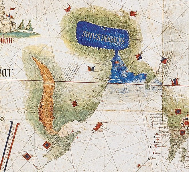
| דעסקריפציע | Enlarged detail showing Red Sea and Persian Gulf as viewed in 1502 in the Cantino World Map. Most important manuscript map surviving from the early Age of Discovery, the Cantino World Map is named for Alberto Cantino, an Italian diplomatic agent in Lisbon who obtained it in 1502 for the Duke of Ferrara. It incorporates extensive new geographical information based on four series of voyages: Columbus to the Caribbean, Pedro Álvarez Cabral to Brazil, Vasco de Gama followed by Cabral to eastern Africa and India, and the brothers Corte-Real to Greenland and Newfoundland. Except for Columbus, all had sailed under the Portuguese flag. |
| דאַטע | (UTC) |
| מקור | |
| שרייבער |
|
| זוהי תמונה מרוטשת, זאת אומרת שהתמונה שונתה בצורה דיגיטלית מהמקור. Modifications: zoom in of Cantino map: the Red sea and Persian Golf. את התמונה המקורית ניתן לראות ב: CantinoPlanisphere.png.
|
|
עבודת אמנות דו-מימדית זו המוצגת בתמונה שוחררה לרשות הציבור בכל העולם בעקבות תאריך מותו של היוצר, או תאריך פרסום היצירה. לפיכך, תצלום היצירה גם הוא ברשות הציבור.
הודעה זו תקפה לגבי התצלומים שנוצרו בארצות הברית, בגרמניה ובמדינות רבות נוספות.
| ||||
יומן העלאה מקורי
This image is a derivative work of the following images:
- File:CantinoPlanisphere.png licensed with PD-Art, PD-old
- 2007-07-01T05:35:29Z Tdmthomas 3528x1656 (12458523 Bytes) {{Information |Description=The most important manuscript map surviving from the early Age of Discovery, the Cantino World Map is named for Alberto Cantino, an Italian diplomatic agent in Lisbon who obtained it in 1502 for the
Uploaded with derivativeFX
היסטאריע פֿון דער טעקע
קליקט אויף א דאטע/צײַט צו זען דאס בילד אזוי ווי עס איז דעמאלסט געווען
| דאַטע/שעה | געמינערטע בילד | געמעסטן | באניצער | קאָמענטאַר | |
|---|---|---|---|---|---|
| איצטיקע | 13:39, 12 דעצעמבער 2009 | | 605 × 666 (318 קילאבייטן) | Uxbona | {{Information |Description= Enlarged detail showing Red Sea and Persian Gulf as viewed in 1502 in the Cantino World Map. Most important manuscript map surviving from the early Age of Discovery, the Cantino World Map is named for Alberto Cantino, an Italia |
טעקע באַניץ
דער פאלגנדער בלאט ניצט די דאזיגע טעקע:
גלאבאלע טעקע־פארווענדונג
די פאלגנדע אנדערע וויקיס ניצן די דאזיקע טעקע:
- באניץ ביי ar.wikipedia.org
- באניץ ביי ca.wikipedia.org
- באניץ ביי ckb.wikipedia.org
- באניץ ביי de.wikipedia.org
- באניץ ביי el.wikipedia.org
- באניץ ביי en.wikipedia.org
- באניץ ביי es.wikipedia.org
- באניץ ביי fa.wikipedia.org
- באניץ ביי fr.wikipedia.org
- באניץ ביי it.wikipedia.org
- באניץ ביי mk.wikipedia.org
- באניץ ביי ms.wikipedia.org
- באניץ ביי pt.wikipedia.org
- באניץ ביי ru.wikipedia.org
- באניץ ביי uk.wikipedia.org